Wednesday, February 18, 2009

The Newseum


This is possibly one of the coolest resources that I've come upon. The Newseum, "— a 250,000-square-foot museum of news — offers visitors an experience that blends five centuries of news history with up-to-the-second technology and hands-on exhibits."

In addition to its physical presence, the Newseum has a home in cyberspace at: http://www.newseum.org/ This information-packed website includes virtual versions of its permanent physical exhibits including Pulitzer Prize-winning photographs; a 9/11 gallery; Berlin Wall gallery; and a Journalists Memorial.

The gallery that I found the most fascinating is the Today's Front Pages Gallery:
Front Pages From Across America and Around the World. Here's the description from the Newseum's website: "More than 700 newspapers transmit their front pages electronically
to the Newseum every day. Up to 80 are enlarged and printed for display
in this gallery — among them one from every state and the District of Columbia
as well as a sampling of international newspapers. Additional front pages
are displayed outside the Newseum on Pennsylvania Avenue."

One can access this gallery online at: http://www.newseum.org/todaysfrontpages/
More than 700 newspapers from around the world electronically submit their front pages on a daily basis. 10 are chosen for a "Top Ten" each day, but visitors to the site can access the front pages via list or map. As a neat bonus, each front page is available as a PDF, allowing one to enlarge and read the stories. A link to each newspaper's website is provided, as well.

This is obviously not the best way of getting a complete "news fix" each day, but that isn't the point; rather, as the site states: "This daily exhibit is part of the Newseum's mission to promote better public understanding of news and journalism. A front page can reveal as much about a newspaper and its community as it does about the day's news. Some days, one story dominates these front pages. But often the stories on page one reflect communities with different interests."

Fascinating!
Kimberley Barker
Friday, February 13, 2009

Bishop's Book Speak (Tony Horwitz's A Voyage Long and Strange reviewed), Installment 5


Click here for Mr. Bishop's podcast review of Tony Horwitz's A Voyage Long and Strange, an enthralling exploration and travelogue of discovery in America, including many of the seemingly forgotten who have been lost to the greater mythology of origin and place in America.

The following titles are also suggested:

Blue Latitudes: Boldly Going Where Captain Cook Has Gone Before
Tony Horwitz
910.45 HORW

Confederates In The Attic: Dispatches From The Unfinished Civil War
Tony Horwitz
973.7 HORWITZ

Skeletons On The Zahara: A True Story of Survival
Dean King
916.48 KING

- Christopher Bishop


Tuesday, February 10, 2009

Google Earth 5.0 Updates: Historical Imager, 3D Mars, Oceans and Narration

The newest version of Google Earth is out and includes some really cool tools for educators and those who like to play with all things geographic. My favorite addition is the historical imagery slider that allows users to view landscapes over time. For most areas the historical imager reveals about ten to twenty years of change with picture quality generally declining as older views are retrieved. A tool such as the historical imager could be used in tandem with Google Earth's overlay option to highlight resources such as the Sanborn Fire Insurance Maps, a collection of maps produced from 1884 to 1922 in various parts of the country, including Georgia, for property claims.

Another new feature is the Oceans view that allows users to see thousands of data points including undersea land forms, shipwrecks, ocean expeditions, National Geographic's ocean atlas and a ton of other great options. The inclusion of video and pictures to illustrate life in the ocean makes for a great learning tool. The information presently available is a good start, however, the input of community users and official institutions should lead to some amazing information.

The addition of 3D Mars is interesting but obviously lacks the detail found on Google Earth. I thought the most interesting view to be information and images of various lander and rover missions. Global maps and imagery are also available.

The final item added to Google Earth is the touring feature that allows users to record a narration while leading viewers through some portion of Google Earth. I love the possibilities of the touring feature for everything from class projects to describing your local neighborhood to others. The touring feature is also incredibly easy to use and very intuitive.

The updates to Google Earth, especially the historical imagery tool, remind me of a photo collection link recently sent to me by a friend. The collection includes older photos from the Battle of Stalingrad overlayed on more recent photos of the city. The resulting collages are fascinating and add a new dynamic to past and present. The other photo collections found on the site are equally interesting and focus on Russian subjects.

- Christopher Bishop

Monday, February 9, 2009

Gliffy, Or How I Learned To Love A Visual Organizer

I love to organize, design and map physical spaces! My need for organization recently led me to create a few maps of the CFL to assist library users in finding physical items housed in the library. Some might say creating maps for a two floor library amounts to overkill, but i noticed a need. Personally, I hate wandering around aimlessly while looking for something despite a nagging feeling I should ask for help. I often wish signs and maps were more abundant for those of us who want to look then ask.

In addition to serving a utilitarian purpose, my endeavour was a first step to creating a map similar to the one for the Lucy Scribner Library. The minimal front page of the LSL map soon discloses an interactive smorgasbord as users delve into the multifaceted finding aid, a resource for locating collections and
connections to additional material. This is truly the Rolls Royce of library finding aids. This is a map for the true library nerd.

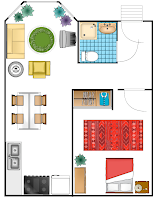
All of the above leads me to a cool new tool I found after creating my library maps in Microsoft's Word program, an application called Gliffy that allows users to create floor plans, flow carts and network diagrams in a simple to use online format. Gliffy certainly isn't revolutionary if you are adept at using Word or Paint for simple maps, charts and diagrams, but it does offer some interesting and easy to use features that expand on tools available in Microsoft Office products. The image uploader, collaboration tools similar to Google Docs and limitless proportions are very helpful. I also like the ability to import various shapes, common images for networking diagrams and an interactive toolbar. The program is free and does not entail any software downloading or storage on your computer. If I would of found Gliffy earlier I probably would of saved myself some time and made a more interesting map. I'll redo the maps soon using Gliffy.


Copper Square Letter D letter E Mobile 013109 087 letter i G N

For those looking for inspiration, this link leads to a LibrayThing collection including books in the CFL chosen because of their connection to design. The selection process may seem haphazard and some of these may not be obtainable from online sources, however, one of the rationales, in my opinion, for a library should be the joy of browsing, of finding items that may be past their prime or hard to find.

The picture of Giles the librarian from Buffy The Vampire Slayer is completely arbitrary and has no real connection to this entry except to illustrate the connection between my status as a male librarian and Giles fan. Photo courtesy of 2010: A Book Odyssey.

The DESIGN logo was made using Spell With Flickr. A cool tool you should check out.

- Christopher Bishop

Friday, February 6, 2009

Video Making With Animoto

I recently attended a very informative Web 2.0 presentation by the IT administrator at The Woodward Academy in College Park, Georgia. The speaker geared the overview towards librarians with applications for anyone interested in using Web 2.0 tools as a platform for learning and collaboration among colleagues, students and friends. The tool I found most interesting and fun is Animoto, an extremely easy to use application for creating professional looking videos using images, music and text. Pictures can be unploaded from your computer, Animoto's collection, or an online site such as Flickr. After adding pictures the user is prompted to add music, either from their collection or your computer, and any text they need to illustrate the images. The whole process of creating the finished video literaly takes a few minutes from start to finish with an option for publishing the final product to Youtube or a personal site such as a blog. Videos can also be e-mailed to others.

The only drawbacks of the site include a limited selection of music and photos hosted by Animoto. There is also a yearly fee ($30) to create videos of more than 30 seconds and to download videos. The positives of the site certainly outweigh any minor drawbacks.

I created the video below (see next post) using images from the Library of Congress collection on Flickr entitled "1930s-40s In Color." The site is a wonderful collection of vintage photographs.

- Christopher Bishop

Connections

Animoto for Education

The Library of Congress' Photostream

Public Domain Collection (Government Sources)

Public Domain Music

Video Making With Animoto